Get Quote
Environmental Geophysics

Hydro-
Geophysics

Groundwater Mapping  ·  Aquifer Prospecting  ·  Contaminant Pathways

30% of Earth's
Fresh Water

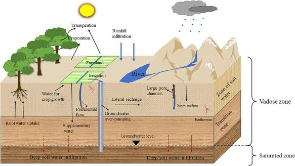
Groundwater makes up approximately 30% of the world's readily available fresh water. It is replenished from the surface and can naturally discharge through springs and seeps, creating oases or wetlands.

The increasing global dependence on groundwater highlights the importance of identifying and mapping water resources. Geophysical methods allow precise detection of water conduits and reservoirs by observing subtle changes in subsurface conductivity linked to water movement.

Geophysics dramatically reduces drilling risk — locate water before you commit to a bore.

Groundwater Zone Breakdown
ZoneDescriptionKey Use
Vadose ZoneUnsaturated — above water tableInfiltration & contamination pathways
Water TableSaturated zone boundaryWater extraction potential
Confined AquiferBounded by impermeable layersHigh-yield drilling targets
Unconfined AquiferOpen to recharge from aboveSeasonal monitoring

Locate Water
Before You Drill

Groundwater prospecting plays a critical role in ensuring a reliable and sustainable water supply, especially in areas where surface water is scarce or unpredictable.

By accurately locating groundwater sources, it offers a dependable supply for agriculture, industry and domestic use — particularly in rural or underserved areas facing drought.

    Electromagnetics (EM) / Resistivity
    Detect aquifers by identifying buried river channels or water-bearing formations
    Seismic Refraction & MASW
    Delineate palaeochannels eroded into bedrock, mapping aquifer boundaries
    Ground Magnetic Surveys
    Identify fractured rock aquifers and potential water-bearing fractures for drilling

Multi-method prospecting — seismic, EM and Resistivity/IP combined to delineate aquifer boundaries prior to drilling

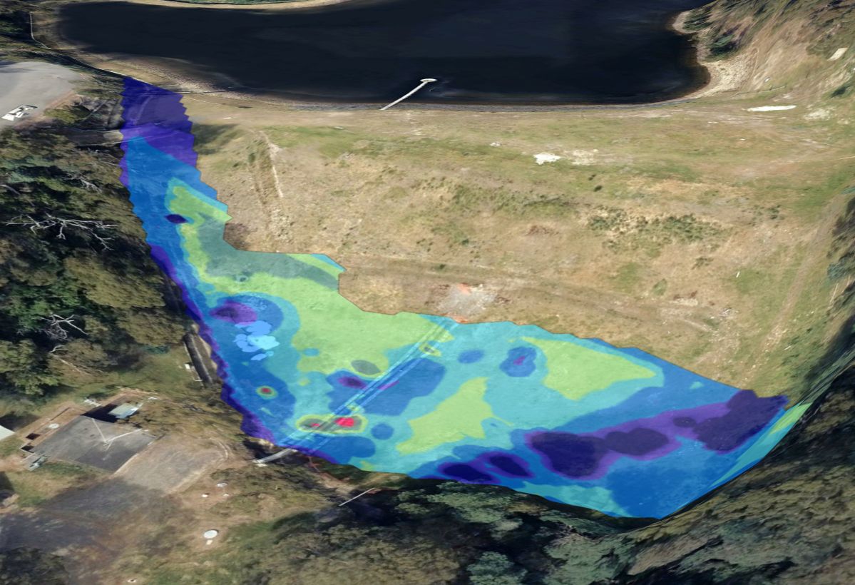
Geophysical monitoring of groundwater flow pathways from water reservoir

Groundwater Seepage &
Contaminant Drainage

Managing seepage from tailings dams and acid rock drainage is crucial — contaminants can infiltrate groundwater rendering it unusable. Remediation often involves installing groundwater bores around mine perimeters to monitor contamination, which can be costly.

Geophysical surveys provide broader, spatially extensive insights into groundwater pathways and their potential interaction with surface contaminants — a valuable supplement to traditional monitoring methods.

    Contamination pathway identification
    Locate migration routes before they spread at mine sites, landfills and oil spill areas
    Cost-effective monitoring
    Extensive spatial coverage reduces borehole dependency
    Improved remediation
    Assess groundwater-surface contaminant interaction for targeted cleanup
    Borehole data extrapolation
    Interpolate between bore results across large areas

Methods Used in
Hydrogeophysics

EM
Electromagnetics / FDEM
Target
Buried channels, saline intrusion, aquifer extent
Depth
0–60 m (instrument dependent)
Output
ECa conductivity maps, 3D volume models
ERT
Electrical Resistivity Tomography
Target
Aquifer geometry, leachate plumes, lithology
Depth
Up to 100+ m depending on array
Output
2D resistivity profiles, 3D inversion models
MASW
Seismic Refraction
Target
Palaeochannels, bedrock depth, water table
Depth
0–40 m typical
Output
Velocity cross-sections, depth-to-bedrock maps
View All Methods

Areas We
Serve in Tasmania

Spaulding Geophysics provides groundwater mapping & prospecting services across Tasmania, from Hobart and Launceston to regional centres, coastal towns, and remote communities statewide.

South & Greater Hobart
  • Hobart
  • Kingston
  • Margate
  • Kettering
  • Bruny Island
  • New Norfolk
  • Sorell
  • Dodges Ferry
North & Launceston
  • Launceston
  • George Town
  • Longford
  • Perth
  • Hadspen
  • Westbury
  • Deloraine
  • Bridport
Northwest Coast
  • Devonport
  • Burnie
  • Ulverstone
  • Wynyard
  • Penguin
  • Smithton
  • Latrobe
  • Port Sorell
East Coast & Midlands
  • Bicheno
  • St Helens
  • Scottsdale
  • Swansea
  • Campbell Town
  • Ross
  • Queenstown
  • Huonville

Spaulding Geophysics delivers on-site groundwater mapping & prospecting across all of Tasmania — including Hobart, Launceston, Devonport, Burnie, Ulverstone, George Town, Longford, Deloraine, Smithton, Wynyard, Bicheno, St Helens, Scottsdale, Queenstown, Huonville, Kingston, Kettering, Bruny Island and surrounding communities. Remote and regional sites welcomed.