The Old
Howrah Tip
EM · Magnetics · pXRF · 3D Modelling · Landfill Boundary Delineation
Uncontrolled Landfill
in Residential Hobart
The Old Howrah Tip was established in 1961 as an uncontrolled landfill for domestic and construction waste, agricultural materials, and significant volumes of used oils. Originally comprising two coastal lagoons within a low-lying swampy area, the site was progressively infilled by waste.
Decommissioned in September 1969, the reclaimed area was converted to sports fields — however, during and after decommissioning, residential subdivisions were developed nearby, with some homes built directly adjacent to or partially over the site.
Concerns have since been raised around potential groundwater contamination and leachate migration from buried waste, including chemicals and oils, with no complete records of lateral extent or waste depth remaining.
There are approximately 20 closed waste landfills in Tasmania with little to no information on the lateral extent and depth of waste material — Howrah is emblematic of this widespread problem.
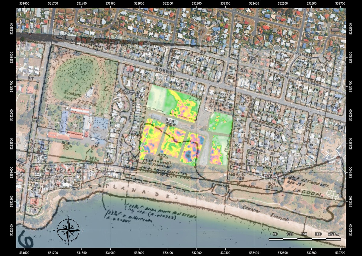
Apparent ECa (mS/m) overlaid on Google Earth — warm colours delineate elevated conductivity from buried waste and leachate; residential properties visible immediately adjacent to the landfill boundary
Closed, Unlined and
Unrecorded
Closed landfills are often unlined — allowing leachate and contaminants to migrate and potentially infiltrate into groundwater. Conventional investigation by drilling risks breaching capping layers and releasing gases. A fully non-invasive multi-method approach was required to map waste extent, depth and contamination pathways without a single intrusive bore.
ECa Conductivity
Mapping
Electromagnetic induction surveys mapped apparent electrical conductivity (ECa) across the site at high spatial resolution. The resulting ECa map immediately revealed the landfill's character through four distinct signatures.
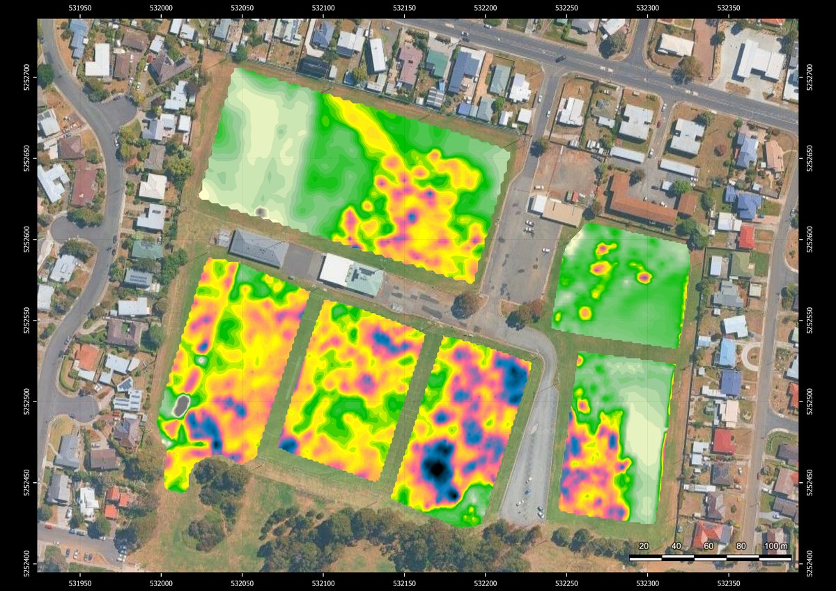
Overhead ECa view — landfill boundary clearly delineated; dark clusters indicate buried metallic objects; linear anomaly at top-left corresponds to groundwater migration pathway
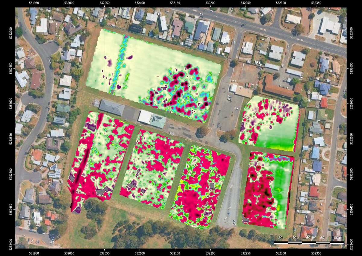
Normalised magnetic susceptibility — concentrated metallic debris appears as intense red anomalies; linear features trace buried pipes extending north through the western flank
Magnetic
Susceptibility Survey
A magnetic susceptibility survey was conducted across the site to characterise the metallic content of the buried waste — independently verifying and extending the ECa findings with a second, complementary dataset.
The magnetic data revealed a high metallic debris composition throughout the waste body, with distinct linear anomalies corresponding to buried infrastructure.
| Feature | Interpretation |
|---|---|
| High susceptibility zones | Concentrated metallic debris — drums, scrap, construction waste |
| Linear feature — western flank | Buried metallic pipe extending north through the site boundary |
| Multiple linear anomalies | Network of buried pipes revealed throughout waste body |
| Northern extent | Consistent with ECa boundary — confirms waste body limit |
Subsurface
Volume Reconstruction
Forward modelling of multi-coil ECa data produced a depth-resolved conductivity volume — resolving the waste body into discrete vertical layers from surface to bedrock. The stacked layer model enables volumetric estimation of waste material and identification of leachate migration depth.
The sunset 3D visualisation shows isosurfaces at multiple ECa thresholds, each surface representing a different conductivity horizon — enabling non-invasive volumetric estimation without a single drill hole.
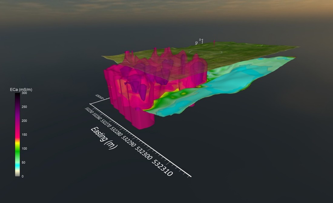
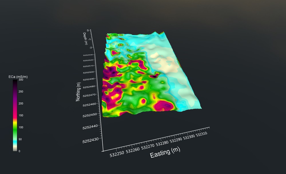
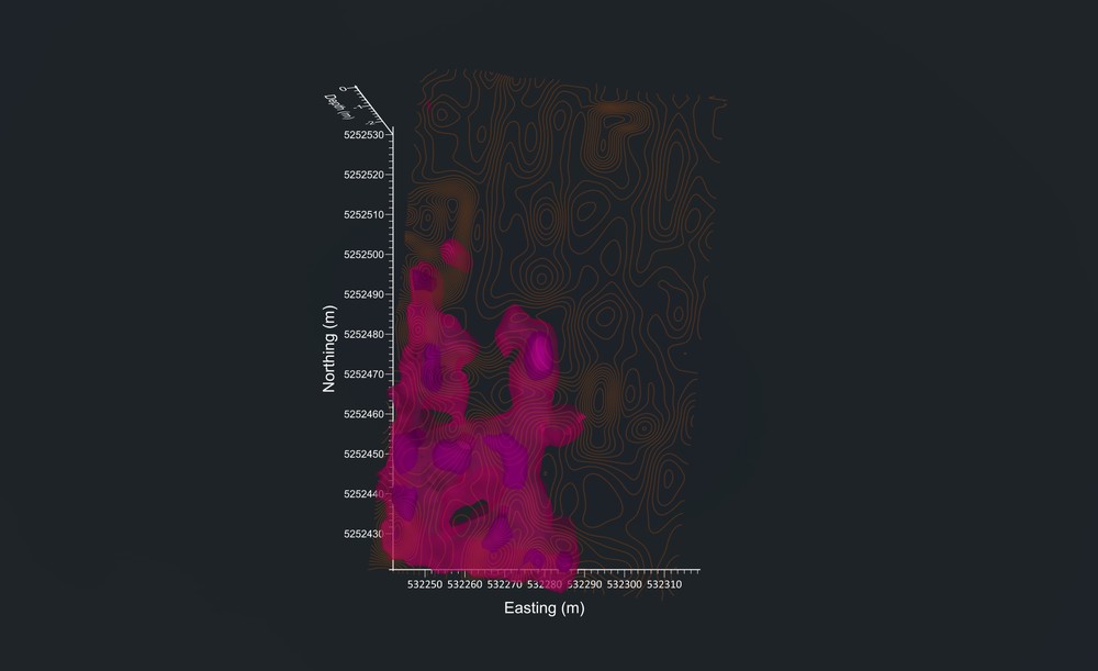
Left: depth-resolved ECa layer stack — shallow to deep conductivity. Top right: isosurface volume at single threshold. Bottom right: overhead isosurface view showing boundary and metallic object anomaly.
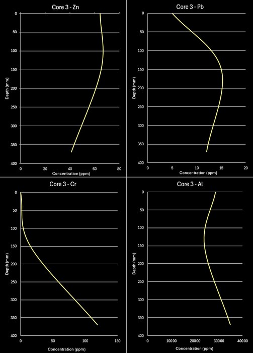
Core depth profiles — element concentration plotted against depth; geochemical breaks correspond to landfill boundaries at urban sportsground
Heavy Element
Quantification
Core samples extracted from the site were analysed using portable X-ray fluorescence (pXRF) to determine whether soil contamination from heavy elements is present in the waste body — and to calculate PPM values at depth.
The pXRF data was integrated with the 3D ECa model as a spatial layer, correlating geochemical anomalies with conductivity anomalies to build a complete contamination picture.
All elements quantified in PPM by pXRF — values calibrated to Tasmania Basalt reference standard with drift correction applied before and after each core run
Complete Site Picture.
Zero Intrusive Works.
Four complementary geophysical and geochemical methods delivered a complete characterisation of the Old Howrah Tip — without a single drill hole breaching the capping layer or disturbing the site.
- Full lateral extent of waste body mapped
- Groundwater migration pathway identified
- Metallic hotspots located
- Sandy/bedrock margins delineated
- High metallic debris confirmed throughout
- Buried pipe network traced
- Western flank infrastructure identified
- Consistent with ECa boundary findings
- Multiple isosurfaces at discrete ECa thresholds
- Depth-to-upper-layer surface generated
- Full waste body volume estimated
- Leachate depth and extent characterised
- 12 heavy elements quantified per core
- Depth profiles revealing contamination stratification
- Geochemistry integrated into 3D model
- PPM values for regulatory comparison