Dam Monitoring
Tasmania
Tailings & TSF · Seepage & Leakage · Embankment Structure · Foundation & Hydro
Dam Investigation
Experts Tasmania
Our geophysical surveys provide continuous spatial information across the dam footprint and its foundation. Electrical resistivity, seismic, induced polarisation, GPR and electromagnetic methods can be integrated to investigate seepage, leakage, saturation, embankment zoning, foundation conditions and subsurface water pathways without excavating the structure.
Dams, embankments and tailings storage facilities (TSFs) contain complex internal structures that are not visible from the surface. Changes in fill material, moisture, foundation geology, drainage zones and preferential groundwater pathways can occur between boreholes and monitoring points.
Geophysics does not replace dam-safety engineering or geotechnical investigation. It adds spatial context between discrete monitoring points and helps identify where targeted investigation should occur.
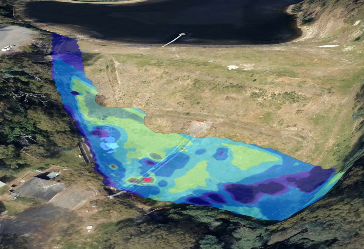
Geophysics can map lateral and vertical changes in subsurface properties across embankments, foundations, tailings and surrounding groundwater systems.
- Water storage dams — earthfill, rockfill and zoned embankments; seepage, leakage and foundation characterisation.
- Tailings storage facilities — moisture, internal zoning, seepage pathways, phreatic-zone investigation and closure studies.
- Hydro & pumped storage — abutments, reservoir margins, leakage pathways, foundation geology and subsurface structures.
- Industrial water & process ponds — embankment condition, groundwater migration and containment assessment.
- >Legacy & abandoned dams — rapid screening before intrusive investigation or remediation.
From Reservoirs
to Tailings
Dam geophysics is particularly valuable where internal construction history is uncertain, monitoring points are widely spaced, or anomalous seepage has been observed but the pathway is not known. Surface geophysics can screen long embankment alignments and large TSF footprints before higher-cost intrusive investigations.
For tailings facilities, electrical properties are influenced by water content, pore-fluid conductivity, mineralogy and tailings texture. The same response can have more than one cause, so interpretation should be constrained using tailings chemistry, piezometric data, construction records and boreholes.
The Right Method
for the Risk
Electrical Resistivity Tomography (ERT) is often the backbone of dam seepage investigations because it provides a continuous model of electrical-property contrasts. Self-potential (SP) adds information about electrokinetic effects associated with groundwater flow.
Induced polarisation, electromagnetic methods, seismic refraction and MASW provide additional constraints on material changes, saturation, tailings properties, foundation structure and weathering. GPR is useful for shallow targets where ground conditions permit, but conductive or clay-rich materials can strongly attenuate radar energy.
Survey design is based on dam geometry, target depth, materials, water chemistry, access and the engineering question — not a default method list.
| Method | Seepage | Structure | Foundation | Tailings |
|---|---|---|---|---|
| ERT | ✓✓✓ | ✓✓✓ | ✓✓✓ | ✓✓✓ |
| IP | ✓✓ | ✓✓✓ | ✓✓ | ✓✓✓ |
| Self-Potential | ✓✓✓ | ✓ | ✓✓ | ✓✓ |
| FDEM / TDEM | ✓✓ | ✓✓✓ | ✓✓ | ✓✓✓ |
| Seismic | ✓ | ✓✓✓ | ✓✓✓ | ✓✓ |
| GPR | ✓ | ✓✓✓ | ✓✓ | ✓ |
Effectiveness depends on target geometry, electrical properties, saturation, salinity, clay content, depth and site noise. Ratings are indicative.
From Field Data
to Engineering Targets
- Review drawings and construction history
- Integrate boreholes, piezometers and seepage records
- Define target depths and survey corridors
- Select complementary methods
- ERT / IP profiles and arrays
- Self-potential mapping
- FDEM / TDEM reconnaissance
- Seismic and GPR for targeted problems
- 2D / 3D resistivity and IP inversion
- SP anomaly analysis
- EM conductivity mapping
- Correlation with topography and existing data
- Georeferenced anomaly maps
- ERT / seismic sections and depth models
- Priority investigation targets
- Technical report and recommendations
Dam & Tailings
Geophysics in Tasmania
Spaulding Geophysics provides dam investigation and subsurface imaging across Tasmania, including mines, hydroelectric infrastructure, water storages, industrial sites and remote tailings facilities.
Tasmania-wide dam geophysics for water storage dams, hydroelectric assets, tailings storage facilities, industrial ponds, embankments and associated groundwater investigations.
Dam Geophysics
Questions
What is dam geophysics?
Dam geophysics uses non-invasive electrical, electromagnetic, seismic and radar methods to investigate embankments, foundations and surrounding ground. The results can identify spatial changes in material, saturation and subsurface electrical or seismic properties.
Can geophysics detect dam seepage?
ERT and self-potential are commonly integrated for seepage investigations. ERT maps electrical-property contrasts, while SP can respond to electrokinetic potentials generated by groundwater flow. Interpretation should be integrated with monitoring and geotechnical information.
What geophysics is used for tailings dams?
ERT, IP, SP, FDEM/TDEM and seismic methods can be combined depending on the TSF and the investigation objective. Tailings chemistry, pore-fluid conductivity, moisture, mineralogy and construction history influence method selection.
Can geophysics map the phreatic surface?
Resistivity data can contribute to interpretation of saturated and unsaturated zones and the phreatic regime. Time-lapse ERT can investigate changes through time and should be calibrated against piezometers and hydraulic measurements.
Does dam geophysics replace drilling?
No. Geophysics is complementary. Its major advantage is providing spatial information between discrete intrusive investigations and helping target boreholes, piezometers and sampling.